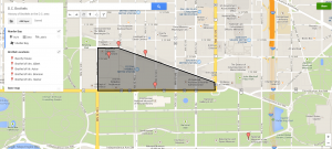
The map Featured above shows the general vicinity of murder bay, as well as some of the locations of the brothels before the neighborhood was cleaned up. Overall this map was fairly easy to make. I was able to find the information necessary to make it through the library of congress and had to transfer it onto a Google map. Creating my own historic narrative though a map I feel gave additional insight into the history of prostitution within D.C. because It illustrates that a large concentration of brothels were focus just outside of the White House in what is now one of the nicer sections of the city. Maps are an excellent way to help people visualize the history of a locations and I think that this map definitely helps in that regard.
