Author Archives: ahinton2

Exhibit

In my exhibit I am going to explore the idea that the reason that prostitutes are known as hookers is due to general Joseph Hooker, a union general who was stationed in D.C. One area where he guarded was known as murder bay due to the sheer number of brothels and gambling dens it contained. It became known as Hookers Division due to the number of soldiers who visited on a regular basis.

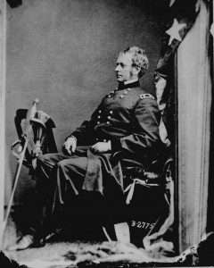
I will include a brief history and a picture of general hooker.

hooker

This is important to the exhibit because the people who look into it are going to want a brief history of the man. It is also always nice to be able to put a face to a name.

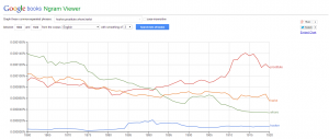
The next Item I will include into my exhibit is an Ngram from google books covering the years 1860-1920 showing the use between hooker, whore, prostitute, and harlot. The reason I choose this time frame is that is the time frame that hookers division existed and the name would have come into play.

graphic


This is a useful and interesting graphic because while they are never the majority, the term hooker has a spike around 1884-1885. This could be used as interpretive support for the use of hookers being named after general hooker.

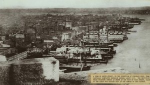
One other piece of information I will include in my exhibit as a piece of contradicting evidence is the idea that hookers are named after Corlears Hook. A neighborhood in New York famous for having brothels that sailors on shore leave would visit.

image-1


this is a picture of Corlears Hook from 1876, the area reputed for its brothels. This fits into the exhibit because it gives people a look into a different view point on the origins of the word and allows them to draw their own conclusions.

These three items, while they will be included into my exhibit, are not the only items I plan on having in it. I hope to obtain more evidence and pictures as I continue to do research into my topic on prostitution in D.C. during the civil war and reconstruction eras.
 

Map

map


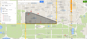
The map Featured above shows the general vicinity of murder bay, as well as some of the locations of the brothels before the neighborhood was cleaned up. Overall this map was fairly easy to make. I was able to find the information necessary to make it through the library of congress and had to transfer it onto a Google map. Creating my own historic narrative though a map I feel gave additional insight into the history of prostitution within D.C. because It illustrates that a large concentration of brothels were focus just outside of the White House in what is now one of the nicer sections of the city. Maps are an excellent way to help people visualize the history of a locations and I think that this map definitely helps in that regard.

Copyright

According to copyright law within the United States, the Calvin and Hobbes comic on the syllabus is protected. Modern copyright law states that anything created is covered for the life of the author plus 70 years. Due to this fact I would make the claim that this comic is therefore violating copyright law as outlined by the U.S. Copyright Office.  They state that, Bill Watterson, being the owner of the copyright for the cartoon has the exclusive right to his work which includes displaying the work publicly. Since the HIST 390 sight is public, I would count this as being a public display, causing it to violate copyright laws. This phenomenon could be avoided if permission is granted by the author, or if the site is password protected or some other measure is taken to remove the site from the public. While this is not a very big violation of copyright law, it is still a violation which needs to be fixed. In the future copyright education should become more wide spread to prevent any serious damage to be done by such light offenses.

Final Topic

For my final project I would like to research the rise and fall of brothels within the red-light district of D.C., and what has become of that district since then.  The first steps I will take to look into this topic is to look for primary sources that can help me trace the origins of the red-light district.  Once I have found these sources and have established it’s roots they will hopefully lead me in the right direction for continued research. The first place I will look for information will be in the mason databases, as well as digging through Google sources to find reliable sites. If done correctly this project to lead to an interesting insight into a portion of D.C.’s history that is not addressed in the textbooks.

Research Topics

Research Topics

washington

When it comes to the development of Washington D.C. there are many interesting topics to choose from, I have chosen three to focus on for my research paper. I believe that they will help understand the rich history of Washington D.C.

The first I would like to examine the rise and fall of the Red Light District within Washington D.C.  I believe that this is an important in understanding the history of D.C. because red light districts existed within virtually all major cities until being deemed illegal and they lead to an interesting insight into the thought process of an era, as well as providing an insight into the lives of a people who are generally ignored in the history texts.  One of the first steps to researching this topic would be to go and look up a general history of Red Light Districts across the country since they all served the same purpose and see what has become of them now.  Another initial research step I could take would be to look up the location of the former red light district within D.C. and then go to the national archives to look for photographs, or newspapers detailing their closing. A search through the GMU Library databases could also yield important results.

The next topic I would like to look into would be the architectural style of the buildings within D.C. and why their certain styles were chosen. This is an important topic because the buildings within a city, especially their architecture, are what give a city it’s feel and define it’s character. It would also be interesting to see a change in the design style in buildings that were built at different times in the history of the city.  A good place to start with this research would be by looking at photographs, or illustrations of the buildings when they are recently completed to see how they fit into the city at the time. Another research topic that would be good to look for would be to look at architectural styles that were popular at the time the building was constructed, and to find cities with similar architecture and see what they are trying to represent.

Finally, I would like to research why architects and city planners chose the locations for the monuments of D.C. This will show insight into D.C. because the monuments, especially the Lincoln, Washington are land marks of the city that people from around the globe recognize. I also think that this would be a worthwhile topic because the national mall was not always the monumental center of the city, and it will be interesting to learn the motivation behind it.  To start researching this topic I should look up articles in newspapers, and reports on the development and building of the monument. One more useful way to begin research would be to look up who created the monuments and then look to see if they made any statements on their placement.

All of these topics could lead to an interesting and insightful history of the Washington D.C. area and will lead to a side of the city not often explored.


D.C. Media Critique

Picture

seq-39

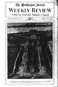
The National Archive is full of many useful articles that can inform people on the rich history of the District of Columbia. The first comes from the Washington Herald with a picture showing the construction of the Lincoln Memorial. This Picture of the Lincoln Memorial  shows the history of D.C. through illustrating the development of the reflecting pool. By using close reading on the caption beneath the picture I was able to determine that the author of the paper has a bias towards the monument because he calls D.C. “the world’s most beautiful capital”. I was also able to determine that it was constructed after the Washington Monument because the picture was taken out of the west facing window at the top of the monument.

Map 

This map, which dates from 1909, depicts the streets and monuments of D.C. that were around at the time of its creation. This map was commissioned by the Inauguration committee of President Taft. I am curious to the reasons behind why President Taft had his inauguration committee commission a map of D.C. Through contextualization I believe that it was to effectively plan out his inauguration because the map includes interesting information such as the length and width of streets in the district. The map is also interesting because unlike many maps of D.C. this one centers around the patent office as opposed to the Capitol Building.

Conclusion

Both of the sources I found provided valuable insight into the history of D.C. While they both provided valuable insight both articles were not created equally. For me it was much easier to read and gather information from the map. All of the information that they provided on the paper made not only contextualizing, but also sourcing, and corroborating much easier to figure out. The picture on the other hand, while it was absolutely fascinating, did not provide me with much background for the picture. It was also lacking in objects that would have allowed to to contextualize it.  However the internet has many great resources that allow those who have questions, that are brought about by the map and picture shown above, receive the answers they are looking for.


Website Reviews

Website 1

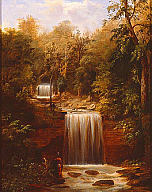
The first website from teachinghistory.org that I visited is for the Milwaukee Art Museum Collection. This website was created, and is maintained by the Milwaukee Art Museum, and it’s copyright is for 2014. This means that the website is not only credible but also up to date. This site is designed for anyone who is interested in going to see the art that is housed in the museum. It has been set up well for this purpose because the hours, prices, exhibits, and much more information that the audience would be interested in is easily available. The website also helps to make the museum more accessible by providing visitors with a taste of what is inside by providing a couple hundred pictures of the thousands of works of art the institution contains. This painting by Robert S. Duncanson titled Minneopa Falls is one of the many housed on the site.

M2007.37

This URL is very good because not only does it make getting to know the museum user accessible, but by also providing a small sample of their work they peak the interest of those who are looking into what the museum has to offer.

Website 2

The second website that I visited from teachinghistory.com is the National Archives site on the power of propaganda during WWII.  Unlike the first website for the art museum this site has not been up kept well and is starting to show its age. The sight only takes up half of the screen on the web browser making everywhere else a plain blue color. On the about the site they state they only have 11 posters and 1 audio file from a much more extensive exhibit that was in the national archive from may of 1994 to February of 1995.  When you delve deeper into the site they have the pictures as promised but no information to go along with them making the website feel more bare than it already is. This site is the perfect example of what happens to a website that at one time had a use but got lost in time, and has since grown obsolete. This is disappointing because with a little bit of rejuvenation this sight could provide some interesting insight into the USA propaganda during WWII.


My digital Past

Introduction

My name is Alexander Hinton and I am currently a sophomore at George Mason studying communications. Throughout my life I have practiced many different forms of internet usage. The earliest form of internet usage I can remember is using Netscape on my families old apple computer. This was back in the time of dial-up so whenever you had to connect to the internet it disabled any phone that was hooked up to the same line.

The Middle School Years

When I was in middle school my family moved to a new home and we were able to attempt to get satellite internet through our cable provider. This form of connectivity was known as DirectWay and it was almost worse than dial-up. While it didn’t tie up any phone lines during use, we would lose signal anytime a cloud passed in front of the dish and it would become slow at high traffic times of the day.

Late Adolescence

The next step in the evolution of my internet voyage was the migration from DirectWay to a broadband card through my mom’s work. This card hooked into a computer through the USB port and is known as VZAccess.  It was more stable and faster than anything prior to it so we decided to keep it. VZAccess was my families main form of connectivity which they still use today.

The Golden Age of Internet Usage

When I came to mason I finally got access to what everyone else considered to be high speed internet. To me it was like something out of a fairy tale. I realized I had the whole of human knowledge at my fingertips. Naturally I took full advantage of this by increasing my usage on social media sights such as www.tumblr.com, facebook.com, and twitter.com. and through tech sights such as gizmodo.com and techcrunch.com. My journey with the internet has been an interesting one and I am very curious to see where it takes me in the future.