Picture
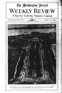
The National Archive is full of many useful articles that can inform people on the rich history of the District of Columbia. The first comes from the Washington Herald with a picture showing the construction of the Lincoln Memorial. This Picture of the Lincoln Memorial shows the history of D.C. through illustrating the development of the reflecting pool. By using close reading on the caption beneath the picture I was able to determine that the author of the paper has a bias towards the monument because he calls D.C. “the world’s most beautiful capital”. I was also able to determine that it was constructed after the Washington Monument because the picture was taken out of the west facing window at the top of the monument.
Map
This map, which dates from 1909, depicts the streets and monuments of D.C. that were around at the time of its creation. This map was commissioned by the Inauguration committee of President Taft. I am curious to the reasons behind why President Taft had his inauguration committee commission a map of D.C. Through contextualization I believe that it was to effectively plan out his inauguration because the map includes interesting information such as the length and width of streets in the district. The map is also interesting because unlike many maps of D.C. this one centers around the patent office as opposed to the Capitol Building.
Conclusion
Both of the sources I found provided valuable insight into the history of D.C. While they both provided valuable insight both articles were not created equally. For me it was much easier to read and gather information from the map. All of the information that they provided on the paper made not only contextualizing, but also sourcing, and corroborating much easier to figure out. The picture on the other hand, while it was absolutely fascinating, did not provide me with much background for the picture. It was also lacking in objects that would have allowed to to contextualize it. However the internet has many great resources that allow those who have questions, that are brought about by the map and picture shown above, receive the answers they are looking for.
